
Google Maps is adding new features for users to use the app to visit national parks. The internet behemoth claims that the improvements intend to assist visitors in getting the information they require. When visiting a national park, such as learning what to do and navigating the park.
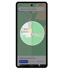
Google Maps will now highlight the complete route with this update. Thus, instead of only highlighting a pin when you search for a path.
How will the new feature of Google Maps work?
According to the firm, this function helps to make it simple for users to determine where a path ends and begins. In addition, how is the route laid out?
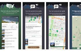
Additionally, visitors can read testimonials and images submitted by Google Maps users. The app will present relevant information from the Maps community, like the type of trail, and its difficulty level. In addition, it’s best for biking, walking, or jogging.
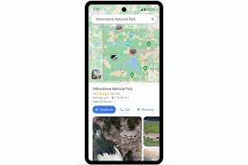
A park’s most popular locations, such as attractions, campgrounds, visitor centers, and trailheads, may now be found quickly due to Google Maps.
Visitors can look up a national park and view photo highlights of its main attractions if they are thinking about visiting one. Tap on the images to access more details like videos and reviews.
About the new feature
Additionally, the app offers customers more accurate directions. Users will start to notice park gates highlighted on the map later this month.
In addition, when visitors ask Maps for walking or cycling directions to a particular path, it will take them right to the trailhead.
Google is also introducing a new method for downloading an offline park map. Users can download the park’s Google Maps listing for offline usage by tapping the “download” button.
Without the use of the internet or cellular data. In addition, they may navigate the area with ease using this option. Google said the download option will show up on park listings later this month.
“These features are coming to all U.S. national parks this April. In addition, they’ll roll out to parks around the world in the coming months,” the business stated in a blog post.
“Google Maps has all the information visitors need in one place. Thus, they can spend more time exploring rather than spending it planning, whether they are making their list of must-see sights or trying to find the best trail for running.”
Closing Thought
It’s important to note that Google Maps is encroaching on AllTrails’ area with the introduction of the new capabilities. Users can access thousands of reviews and photos from the audience on the mobile app for fitness and travel. AllTrails is not limited to national parks, so Google is still a relatively new player.
As part of the announcement, Google revealed that based on data from Google Maps, the Great Smoky Mountains National Park is the best national park in the nation.
Bryce Canyon National Park, Glacier Bay National Park, Kenai Fjords National Park, Rocky Mountain National Park, Acadia National Park, Badlands National Park, Mount Rainier National Park, Carlsbad Caverns National Park, and Grand Teton National Park are the next parks after the park.